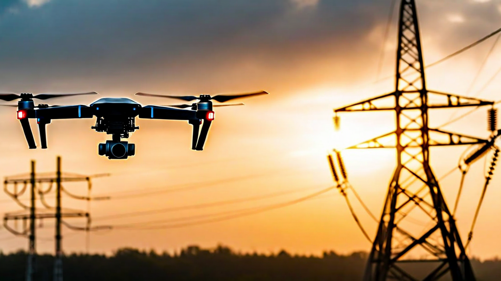
Industrial inspection is one of the most compelling applications of commercial drone technology, and also one of the most technically demanding. Energy infrastructure, telecommunications towers, bridges, pipelines, and manufacturing facilities all require regular inspection to ensure safety and compliance — but traditional inspection methods are expensive, slow, and in many environments, genuinely dangerous for human workers.
Drones have the potential to transform this landscape fundamentally. A properly equipped and operated UAV can inspect a transmission tower in minutes rather than hours, capture data that would be physically impossible for a human inspector to obtain, and do so without requiring personnel to work at height or in proximity to energized equipment. But realizing this potential requires a systematic understanding of the technology, the operational requirements, and the enterprise workflows that must be built around UAV inspection programs. This guide provides that framework.
Understanding the Industrial Inspection Use Case
Before selecting hardware or software, enterprise teams need a clear-eyed assessment of what they are actually trying to accomplish. Industrial drone inspection encompasses a wide range of applications, and the technical requirements differ substantially between them. A pipeline corrosion survey has very different data requirements than a wind turbine blade inspection or a high-voltage transmission line patrol.
The primary variables that define an inspection use case are the type of defect or condition being assessed, the spatial resolution required to reliably detect it, the physical environment in which the inspection must be conducted, and the frequency with which inspections need to occur. A hairline crack in a turbine blade requires close-range, ultra-high-resolution imagery and precise proximity flight. A broad survey of a pipeline corridor for ground subsidence or vegetation encroachment requires wide-area coverage at moderate resolution. Understanding these requirements upfront determines everything from drone selection to payload configuration to flight altitude and speed.
Industrial environments also introduce operational constraints that are less common in consumer or commercial drone applications. Electromagnetic interference from high-voltage equipment can disrupt GPS and magnetometer readings. Physical obstructions including cables, guy wires, and structural elements create collision risk. Industrial facilities often have restricted airspace requirements and site access protocols that must be accommodated within inspection workflows.
Payload Selection and Sensor Configuration
The sensor payload determines what data the drone collects and therefore what insights the inspection can produce. Most industrial inspection programs use one or more of four primary sensor categories: optical cameras, thermal cameras, LiDAR scanners, and multispectral sensors.
High-resolution optical cameras remain the workhorse of visual inspection. Modern inspection-grade cameras achieve 45–61 megapixels of resolution, enabling close-proximity inspection imagery that can resolve fine cracks, surface degradation, and component condition with sub-millimeter clarity when captured from appropriate distances. Zoom lenses extend the effective inspection range, allowing operators to capture detailed imagery of specific components without requiring the drone to fly to potentially hazardous close proximity.
Thermal cameras detect heat signatures, making them valuable for a different category of inspection applications. Electrical components operating outside normal temperature ranges are often precursors to failure — thermography can identify hot spots on transmission lines, substations, and electrical panels that would not be visible in optical imagery. Thermal inspection is also used extensively in building envelope surveys to identify insulation gaps and moisture infiltration, and in solar farm monitoring to detect underperforming panels.
LiDAR sensors emit laser pulses and measure the time of return to generate precise three-dimensional point clouds of the inspection environment. This technology is particularly valuable for structural surveys where dimensional accuracy is critical — LiDAR-based surveys of bridges, dams, and industrial structures can detect millimeter-scale deformation over time when compared to baseline datasets. LiDAR also performs reliably in conditions where optical imagery is degraded, such as dust-laden environments or areas of high contrast that challenge camera exposure.
Mission Planning for Industrial Environments
Effective industrial inspection requires systematic mission planning that accounts for the specific physical environment, the required coverage, safety constraints, and data quality requirements. Improvised or ad hoc flight operations in industrial environments carry elevated risk and typically produce inconsistent data that is difficult to process systematically.
The starting point is a thorough site assessment. For new inspection sites, this should include a ground-level walkthrough to identify physical hazards, document obstructions, establish safe landing zones, and identify any local interference sources that might affect drone navigation. Increasingly, this assessment phase is itself being automated — ground-level LiDAR scans or lower-resolution preliminary drone flights can generate site maps that inform detailed mission planning before the primary inspection flight begins.
Mission planning software translates the inspection requirements into specific flight paths, waypoints, altitudes, and sensor parameters. For linear assets like pipelines or transmission corridors, corridor-following algorithms define overlapping parallel flight lines that ensure complete coverage while maintaining consistent altitude above ground level. For vertical structures like towers and wind turbines, helical flight paths or structured orbit patterns enable systematic coverage of all surfaces from multiple angles.
The relationship between flight altitude, speed, ground sample distance (GSD), and image overlap is fundamental to photogrammetric quality. A typical inspection for visual assessment purposes requires GSD of 5–10mm per pixel for general condition assessment, and below 2mm per pixel for detailed defect detection. Achieving these resolutions at operationally practical distances requires cameras with adequate megapixel count and appropriate focal length selection. These parameters, combined with target image overlap ratios of 75–85% in both flight and cross-track directions for photogrammetric reconstruction, define the minimum flight parameters for any given mission.
Autonomy and Operational Safety
Manual drone flight in industrial environments requires skilled pilots with significant training and experience. Maintaining precise position control within a few meters of energized transmission infrastructure, navigating around complex structural geometries, and managing sensor operation simultaneously places demands on pilot attention that create both operational inefficiency and safety risk. Autonomous flight systems that handle navigation and positioning precisely, leaving the operator to monitor mission progress and manage exceptions, substantially improve both safety and data quality.
Modern industrial inspection drones incorporate multiple layers of autonomy: GPS-based waypoint navigation for open-area operations, sensor fusion combining GPS, inertial measurement, barometric altitude, and optical flow for precise positioning in GPS-degraded environments, and collision avoidance systems using ultrasonic, infrared, or radar sensors to detect and respond to obstacles. The integration of these systems must be carefully validated for each operational environment — GPS-inertial fusion that performs reliably outdoors may require tuning for the magnetic interference profiles of specific industrial facilities.
Return-to-home and fail-safe behaviors are critical for industrial operations where a drone failure could result in contact with energized equipment or damage to critical infrastructure. Enterprise-grade systems should define clear fail-safe trees that specify drone behavior for communications loss, low battery, GPS loss, and other contingencies, with defaults tuned to the specific risk profile of the operational environment.
Data Management and Integration Workflows
The value of industrial drone inspection is realized not in the flight itself, but in the analysis and use of the data collected. An inspection program that produces thousands of images or gigabytes of LiDAR data but lacks the workflows to process, store, retrieve, and act on that data delivers only a fraction of its potential value.
Post-flight data processing for photogrammetric inspection programs typically involves structure-from-motion (SfM) reconstruction to generate orthomosaic maps and 3D models from overlapping imagery. This processing is computationally intensive — a single transmission tower inspection captured at high resolution may produce 500–2,000 images that require several hours of processing to generate the 3D point cloud and textured model used for analysis. Cloud-based processing infrastructure that can scale compute resources to match processing demand is generally more practical than maintaining on-premises processing capacity sized for peak load.
Defect detection and annotation is evolving rapidly with the application of machine learning. AI-based defect detection algorithms trained on large datasets of annotated inspection imagery can flag potential defects for human review, dramatically reducing the time required to analyze inspection data and improving the consistency of defect identification compared to manual review. The performance of these algorithms varies significantly based on defect type, training data quality, and operational context — organizations deploying AI-assisted inspection should validate performance systematically against their specific asset types and defect categories.
Building the Business Case: ROI of Industrial Drone Inspection
Enterprise investment in drone inspection programs needs to be justified by demonstrable return on investment. The financial case typically rests on three categories of benefit: direct cost reduction relative to traditional inspection methods, reduction in unplanned downtime through earlier defect detection, and improved safety outcomes reducing liability and regulatory risk.
Direct cost comparison studies across the energy and infrastructure sectors consistently show drone inspection costing 40–70% less than equivalent rope access or scaffolding-based inspection, primarily through reduced labor time and elimination of access equipment costs. For high-frequency inspection requirements — such as the monthly or quarterly patrol of extensive transmission corridors — these savings compound significantly over time.
The preventive maintenance value of drone inspection is more difficult to quantify but often represents the largest component of total ROI. Early detection of developing defects — a corroding anchor point, a damaged insulator, a developing crack — enables planned maintenance interventions that cost a fraction of emergency repair or unplanned failure scenarios. For major energy infrastructure components where unplanned failure can cost millions of dollars in repair costs and lost generation revenue, even modest improvements in early defect detection rates can justify significant inspection technology investment.
Key Takeaways
- Industrial drone inspection requirements vary significantly by asset type — define the specific defect detection needs before selecting hardware and software
- Payload selection should match sensor capabilities to inspection requirements: optical for visual assessment, thermal for electrical anomalies, LiDAR for dimensional accuracy
- Systematic mission planning is essential for consistent data quality and operational safety in industrial environments
- Autonomous flight capabilities reduce pilot workload and improve safety for close-proximity industrial operations
- Data management and analytics workflows are critical to realizing the full value of inspection programs
- Documented ROI cases show 40–70% cost reduction versus traditional access-based inspection methods
Conclusion
Industrial drone inspection has moved well beyond proof-of-concept into mainstream enterprise adoption. The organizations achieving the greatest value from these programs share a common characteristic: they approached implementation systematically, investing in mission planning, operational protocols, data management infrastructure, and team training alongside the drone hardware itself. The technology is capable; the differentiator between programs that deliver sustained value and those that plateau after initial deployment is the rigor of the surrounding operational framework.
As autonomy capabilities continue to advance and regulatory frameworks for BVLOS operations mature, the scope of what industrial drone inspection can accomplish will expand further. Organizations that build systematic inspection capabilities today are positioning themselves for compounding advantages as the technology evolves — building institutional knowledge, annotated inspection datasets, and operational expertise that will accelerate their adoption of next-generation capabilities as they become available.